
Understanding aviation weather reportingA weather brief should be part of any preparation for flight. Here it is important to know your way around aviation weather reporting - what is available and how is it read. In aviation, weather service is a combined effort of the National Weather Service (NWS), the Federal Aviation Administration (FAA), the Department of Defense (DOD), and other aviation groups and individuals. Because of the increasing need for worldwide weather services, foreign weather organizations also provide vital input. While weather forecasts are not 100 percent accurate, meteorologists, through careful scientific study and computer modeling, have the ability to predict the weather patterns, trends, and characteristics with increasing accuracy. Through a complex system of weather services, government agencies, and independent weather observers, pilots and other aviation professionals receive the benefit of this vast knowledge base in the form of up-to-date weather reports and forecasts. These reports and forecasts enable pilots to make informed decisions regarding weather and flight safety. Observations The data gathered from surface and upper altitude observations form the basis of all weather forecasts, advisories, and briefings. There are three types of weather observations: surface, upper air, and radar. Surface aviation weather observations Surface aviation weather observations (METARs) are a compilation of weather elements of the current weather at ground stations across the United States. The network is made up of government run facilities and privately contracted facilities that provide up-to-date weather information. Automated weather sources such as automated weather observing systems (AWOS) and automated surface observing systems (ASOS), as well as other automated facilities, also play a major role in the gathering of surface observations. Surface observations provide local weather conditions and other relevant information. This information includes the type of report, station identifier, date and time, modifier (as required), wind, visibility, runway visual range (RVR), weather phenomena, sky condition, temperature/dewpoint, altimeter reading, and applicable remarks. The information gathered for the surface observation may be from a person, an automated station, or an automated station that is updated or enhanced by a weather observer. In any form, the surface observation provides valuable information about airports around the country. Upper air observations Observations of upper air weather prove to be more challenging than surface observations. There are only two methods by which upper air weather phenomena can be observed: radiosonde observations and pilot weather reports (PIREPs). Using radio telemetry, radiosonde observations are made by sounding balloons from which weather data is received twice daily. These upper air observations provide temperature, humidity, pressure, and wind data for heights up to and above 100,000 feet. In addition to this, pilots provide vital information regarding upper air weather observations. Pilots remain the only real-time source of information regarding turbulence, icing, and cloud heights, which is gathered from pilots in flight, through the filing of pilot weather reports or PIREPs. Together, pilot reports and radiosonde observations provide information on upper air conditions important for flight planning. Many U.S. and international airlines have equipped their aircraft with instrumentation that automatically transmits in-flight weather observations through the DataLink system to the airline dispatcher who disseminates the data to appropriate weather forecasting authorities. Radar observations Weather observers use three types of radar to provide information about precipitation, wind, and weather systems. The WSR-88D NEXRAD radar, commonly called Doppler radar, provides in-depth observations that inform surrounding communities of impending weather. FAA terminal doppler weather radar (TDWR), installed at some major airports around the country, also aids in providing severe weather alerts and warnings to airport traffic controllers. Terminal radar ensures pilots are aware of wind shear, gust fronts, and heavy precipitation, all of which are dangerous to arriving and departing aircraft. The third type of radar commonly used in the detection of precipitation is the FAA airport surveillance radar. This radar is used primarily to detect aircraft; however, it also detects the location and intensity of precipitation which is used to route aircraft traffic around severe weather in an airport environment. Service outlets Service outlets are government or private facilities that provide aviation weather services. Several different government agencies, including the Federal Aviation Administration (FAA), National Oceanic and Atmospheric Administration (NOAA), and the National Weather Service (NWS) work in conjunction with private aviation companies to provide different means of accessing weather information. FAA Flight Service Station The FAA Flight Service Station (FSS) is the primary source for preflight weather information. A preflight weather briefing from an automated FSS (AFSS) can be obtained 24 hours a day by calling 1-800-WX BRIEF almost anywhere in the U.S. In areas not served by an AFSS, National Weather Service facilities may provide pilot weather briefings. Telephone numbers for NWS facilities and additional numbers for FSSs/AFSSs can be found in the Airport/Facility Directory (A/FD) or in the U.S. Government section of the telephone book. Flight Service Stations also provide in-flight weather briefing services, as well as scheduled and unscheduled weather broadcasts. An FSS may also furnish weather advisories to flights within the FSS region of authority. Transcribed Information Briefing Service (TIBS) The Transcribed Information Briefing Service (TIBS) is a service which is prepared and disseminated by selected Automated Flight Service Stations. It provides continuous telephone recordings of meteorological and aeronautical information. Specifically, TIBS provides area and route briefings, airspace procedures, and special announcements. It is designed to be a preliminary briefing tool and is not intended to replace a standard briefing from an FSS specialist. The TIBS service is available 24 hours a day and is updated when conditions change, but it can only be accessed by a TOUCH-TONE© phone. The phone numbers for the TIBS service are listed in the A/FD. Direct User Access Terminal Service (DUATS) The Direct User Access Terminal Service, which is funded by the FAA, allows any pilot with a current medical certificate to access weather information and file a flight plan via computer. Two methods of access are available to connect with DUATS. The first is on the Internet through DynCorp at http://www.duats.com or Data Transformation Corporation at http://www.duat.com. The second method requires a modem and a communications program supplied by a DUATS provider. To access the weather information and file a flight plan by this method, pilots use a toll free telephone number to connect the user’s computer directly to the DUATS computer. The current vendors of DUATS service and the associated phone numbers are listed in Chapter 7 of the Aeronautical Information Manual (AIM).
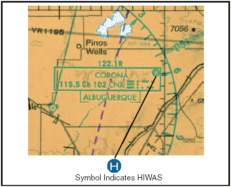
Enroute Flight Advisory Service A service specifically designed to provide timely enroute weather information upon pilot request is known as the enroute flight advisory service (EFAS), or Flight Watch. EFAS provides a pilot with weather advisories tailored to the type of flight, route, and cruising altitude. EFAS can be one of the best sources for current weather information along the route of flight. A pilot can usually contact an EFAS specialist from Hazardous In-flight Weather Advisory (HIWAS) HIWAS is a national program for broadcasting hazardous weather information continuously over selected navaids. The broadcasts include advisories such as AIRMETS, SIGMETS, convective SIGMETS, and urgent PIREPs. These broadcasts are only a summary of the information, and pilots should contact an FSS or EFAS for detailed information. Navaids that have HIWAS capability are depicted on sectional charts with an “H” in the upper right corner of the identification box.
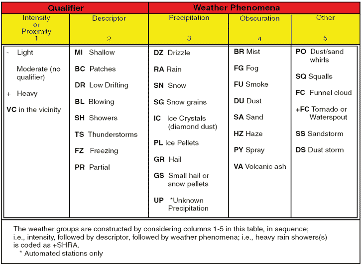
Figure 1: HIWAS availability is shown on sectional chart. Transcribed Weather Broadcast (TWEB) A transcribed weather broadcast is a weather report transmitted continuously over selected navaids. On a sectional chart, a “T” in the upper right-hand corner of the navaid box indicates TWEB availability. TWEB weather usually consists of route-orientated data including route forecasts, forecast outlook, winds aloft, and other selected weather reports for an area within 50 nautical miles (NM) of the FSS or for a 50-mile wide corridor along a specific route. A TWEB forecast is valid for 12 hours and is updated four times a day. Weather briefings Prior to every flight, pilots should gather all information vital to the nature of the flight. This includes an appropriate weather briefing obtained from a specialist at an FSS, AFSS, or NWS. For weather specialists to provide an appropriate weather briefing, they need to know which of the three types of briefings is needed—a standard briefing, an abbreviated briefing, or an outlook briefing. Other helpful information is whether the flight is visual flight rule (VFR) or instrument flight rule (IFR), aircraft identification and type, departure point, estimated time of departure (ETD), flight altitude, route of flight, destination, and estimated time en route (ETE). This information is recorded in the flight plan system, and a note is made regarding the type of weather briefing provided. If necessary, it can be referenced later to file or amend a flight plan. It is also used when an aircraft is overdue or is reported missing. Standard briefing A standard briefing is the most complete report and provides the overall weather picture. This type of briefing should be obtained prior to the departure of any flight and should be used during flight planning. A standard briefing provides the following information in sequential order if it is applicable to the route of flight. 1. Adverse Conditions—This includes information about adverse conditions that may influence a decision to cancel or alter the route of flight. Adverse conditions includes significant weather, such as thunderstorms or aircraft icing, or other important items such as airport closings. 2. VFR Flight NOT RECOMMENDED—If the weather for the route of flight is below VFR minimums, or if it is doubtful the flight could be made under VFR conditions due to the forecast weather, the briefer may state that VFR is not recommended. It is the pilot’s decision whether or not to continue the flight under VFR, but this advisory should be weighed carefully. 3. Synopsis—The synopsis is an overview of the larger weather picture. Fronts and major weather systems that affect the general area are provided. 4. Current Conditions—This portion of the briefing contains the current ceilings, visibility, winds, and temperatures. If the departure time is more than 2 hours away, current conditions will not be included in the briefing. 5. En Route Forecast—The en route forecast is a summary of the weather forecast for the proposed route of flight. 6. Destination Forecast—The destination forecast is a summary of the expected weather for the destination airport at the estimated time of arrival (ETA). 7. Winds and Temperatures Aloft—Winds and temperatures aloft is a report of the winds at specific altitudes for the route of flight. However, the temperature information is provided only on request. 8. Notices to Airmen—This portion supplies NOTAM information pertinent to the route of flight which has not been published in the Notice to Airmen publication. Published NOTAM information is provided during the briefing only when requested. 9. ATC Delays—This is an advisory of any known air traffic control (ATC) delays that may affect the flight. 10. Other Information—At the end of the standard briefing, the FSS specialist will provide the radio frequencies needed to open a flight plan and to contact en route flight advisory service (EFAS). Any additional information requested is also provided at this time. Abbreviated briefing An abbreviated briefing is a shortened version of the standard briefing. It should be requested when a departure has been delayed or when specific weather information is needed to update the previous briefing. When this is the case, the weather specialist needs to know the time and source of the previous briefing so the necessary weather information will not be omitted inadvertently. Outlook briefing An outlook briefing should be requested when a planned departure is 6 or more hours away. It provides initial forecast information that is limited in scope due to the timeframe of the planned flight. This type of briefing is a good source of flight planning information that can influence decisions regarding route of flight, altitude, and ultimately the go, no-go decision. A follow-up briefing prior to departure is advisable since an outlook briefing generally only contains information based on weather trends and existing weather in geographical areas at or near the departure airport. Aviation weather reports Aviation weather reports are designed to give accurate depictions of current weather conditions. Each report provides current information that is updated at different times. Some typical reports are aviation routine weather reports (METAR), pilot weather reports (PIREPs), and radar weather reports (SDs). Aviation routine weather report (METAR) An aviation routine weather report, or METAR, is an observation of current surface weather reported in a standard international format. While the METAR code has been adopted worldwide, each country is allowed to make modifications to the code. Normally, these differences are minor but necessary to accommodate local procedures or particular units of measure. This discussion of METAR will cover elements used in the United States. Example: METAR KGGG 161753Z AUTO 14021G26 3/4SM +TSRA BR BKN008 OVC012CB 18/17 A2970 RMK PRESFR A typical METAR report contains the following information in sequential order: 1. Type of Report—There are two types of METAR reports. The first is the routine METAR report that is transmitted every hour. The second is the aviation selected special weather report (SPECI). This is a special report that can be given at any time to update the METAR for rapidly changing weather conditions, aircraft mishaps, or other critical information. 2. Station Identifier—Each station is identified by a four-letter code as established by the International Civil Aviation Organization (ICAO). In the 48 contiguous states, a unique three-letter identifier is preceded by the letter “K.” For example, 3. Date and Time of Report—The date and time (161753Z) are depicted in a six-digit group. The first two digits of the six-digit group are the date. The last four digits are the time of the METAR, which is always given in Coordinated Universal Time (UTC). A “Z” is appended to the end of the time to denote the time is given in Zulu time (UTC) as opposed to local time. 4. Modifier—Modifiers denote that the METAR came from an automated source or that the report was corrected. If the notation “AUTO” is listed in the METAR, the report came from an automated source. It also lists “AO1” or “AO2” in the remarks section to indicate the type of precipitation sensors employed at the automated station. When the modifier “COR” is used, it identifies a corrected report sent out to replace an earlier report that contained an error. Example: METAR KGGG 161753Z COR 5. Wind—Winds are reported with five digits (14021) unless the speed is greater than 99 knots, in which case the wind is reported with six digits. The first three digits indicate the direction the wind is blowing in tens of degrees. If the wind is variable, it is reported as “VRB.” The last two digits indicate the speed of the wind in knots (KT) unless the wind is greater than 99 knots, in which case it is indicated by three digits. If the winds are gusting, the letter “G” follows the windspeed (G26). After the letter “G,” the peak gust recorded is provided. If the wind varies more than 60° and the windspeed is greater than 6 knots, a separate group of numbers, separated by a “V,” will indicate the extremes of the wind directions. 6. Visibility—The prevailing visibility (3/4 SM) is reported in statute miles as denoted by the letters “SM.” It is reported in both miles and fractions of miles. At times, RVR, or runway visual range is reported following the prevailing visibility. RVR is the distance a pilot can see down the runway in a moving aircraft. When RVR is reported, it is shown with an R, then the runway number followed by a slant, then the visual range in feet. For example, when the RVR is reported as R17L/1400FT, it translates to a visual range of 1,400 feet on runway 17 left. 7. Weather—Weather can be broken down into two different categories: qualifiers and weather phenomenon (+TSRA BR). First, the qualifiers of intensity, proximity, and the descriptor of the weather will be given. The intensity may be light (-), moderate ( ), or heavy (+). Proximity only depicts weather phenomena that are in the airport vicinity. The notation “VC” indicates a specific weather phenomenon is in the vicinity of 5 to 10 miles from the airport. Descriptors are used to describe certain types of precipitation and obscurations. Weather phenomena may be reported as being precipitation, obscurations, and other phenomena such as squalls or funnel clouds. Descriptions of weather phenomena as they begin or end, and hailstone size are also listed in the remarks sections of the report.
Figure 2: Descriptors and weather phenomena used in a typical METAR. 8. Sky Condition—Sky condition (BKN008 OVC012CB) is always reported in the sequence of amount, height, and type or indefinite ceiling/height (vertical visibility). The heights of the cloud bases are reported with a three-digit number in hundreds of feet above the ground. Clouds above 12,000 feet are not detected or reported by an automated station. The types of clouds, specifically towering cumulus (TCU) or cumulonimbus (CB) clouds, are reported with their height. Contractions are used to describe the amount of cloud coverage and obscuring phenomena. The amount of sky coverage is reported in eighths of the sky from horizon to horizon.
Figure 3: Reportable contractions for sky condition. 9. Temperature and Dewpoint—The air temperature and dewpoint are always given in degrees Celsius (18/17). Temperatures below 0°C are preceded by the letter “M” to indicate minus. 10. Altimeter Setting—The altimeter setting is reported as inches of mercury in a four-digit number group (A2970). It is always preceded by the letter “A.” Rising or falling pressure may also be denoted in the remarks sections as “PRESRR” or “PRESFR” respectively. 11. Remarks—Comments may or may not appear in this section of the METAR. The information contained in this section may include wind data, variable visibility, beginning and ending times of particular phenomenon, pressure information, and various other information deemed necessary. An example of a remark regarding weather phenomenon that does not fit in any other category would be: OCNL LTGICCG. This translates as occasional lightning in the clouds, and from cloud to ground. Automated stations also use the remarks section to indicate the equipment needs maintenance. The remarks section always begins with the letters “RMK.” Example: METAR BTR 161753Z 14021G26 3/4SM -RA BR BKN008 OVC012 18/17 A2970 RMK PRESFR Explanation:
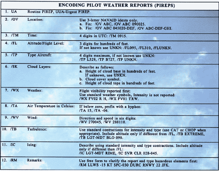
Pilot weather reports (PIREPs) Pilot weather reports provide valuable information regarding the conditions as they actually exist in the air, which cannot be gathered from any other source. Pilots can confirm the height of bases and tops of clouds, locations of wind shear and turbulence, and the location of in-flight icing. If the ceiling is below 5,000 feet, or visibility is at or below 5 miles, ATC facilities are required to solicit PIREPs from pilots in the area. When unexpected weather conditions are encountered, pilots are encouraged to make a report to an FSS or ATC. When a pilot weather report is filed, the ATC facility or FSS will add it to the distribution system to brief other pilots and provide in-flight advisories. PIREPs are easy to file and a standard reporting form outlines the manner in which they should be filed.
Figure 4: PIREP encoding and decoding. Figure 4 shows the elements of a PIREP form. Item numbers one through five are required information when making a report, as well as at least one weather phenomenon encountered. PIREPs are normally transmitted as an individual report, but may be appended to a surface report. Pilot reports are easily decoded and most contractions used in the reports are self-explanatory. Example: UA/OV GGG 090025/ M 1450/ FL 060/ TP C182/ SK 080 OVC/ WX FV 04R/ TA 05/ WV 270030/ TB LGT/ RM HVY RAIN Explanation:
Radar weather reports (SD) Areas of precipitation and thunderstorms are observed by radar on a routine basis. Radar weather reports are issued by radar stations at 35 minutes past the hour, with special reports issued as needed. Radar weather reports provide information on the type, intensity, and location of the echo top of the precipitation.
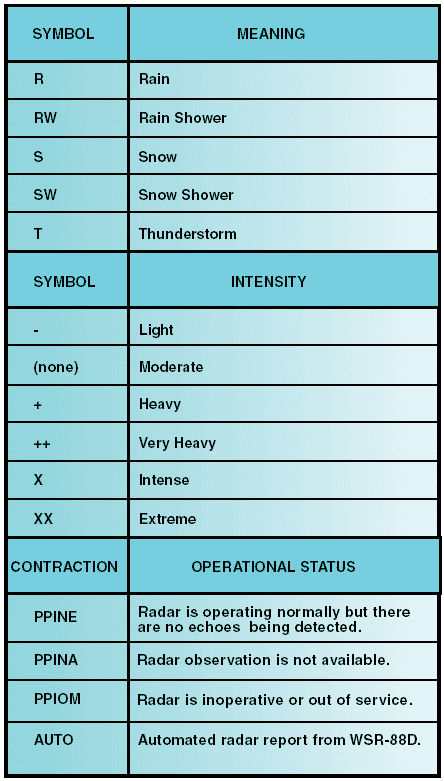
Figure 5: Radar weather report codes. These reports may also include direction and speed of the area of precipitation as well as the height and base of the precipitation in hundreds of feet MSL. RAREPs are especially valuable for preflight planning to help avoid areas of severe weather. However, radar only detects objects in the atmosphere that are large enough to be considered precipitation. Cloud bases and tops, ceilings, and visibility are not detected by radar. A typical RAREP will include:
1. Line (LN)—A line of precipitation echoes at least 30 miles long, at least four times as long as it is wide, and at least 25 percent coverage within the line. 2. Area (AREA)—A group of echoes of similar type and not classified as a line. 3. Single Cell (CELL)—A single isolated convective echo such as a rain shower.
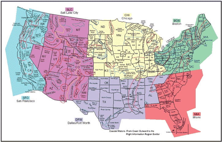
Example: TLX 1935 LN 8 TRW++ 86/40 199/115 20W C2425 MTS 570 AT 159/65 AUTO ^MO1 NO2 ON3 PM34 QM3 RL2= Explanation: The radar report gives the following information: The report is automated from Thunderstorms and very heavy rain showers are indicated. The next set of numbers indicate the azimuth that defines the echo (86° at 40 NM and 199° at 115 NM). Next, the dimension of this echo is given as 20 nautical miles wide (10 nautical miles on either side of the line defined by the azimuth and range). The cells within the line are moving from 240° at 25 knots. The maximum top of the precipitation, as determined by radar and satellite, is 57,000 feet and it is located on the 159° radial, 65 NM out. The last line indicates the intensity of the precipitation, for example in grid QM the intensity is 3 or heavy precipitation. (1 is light and 6 is extreme.) Aviation forecasts Observed weather condition reports are often used in the creation of forecasts for the same area. A variety of different forecast products are produced and designed to be used in the preflight planning stage. The printed forecasts that pilots need to be familiar with are the terminal aerodrome forecast (TAF), aviation area forecast (FA), in-flight weather advisories (SIGMET, AIRMET), and the winds and temperatures aloft forecast (FD). Terminal Aerodrome Forecasts (TAF) A terminal aerodrome forecast is a report established for the 5 statute mile radius around an airport. TAF reports are usually given for larger airports. Each TAF is valid for a 24-hour time period, and is updated four times a day at 0000Z, 0600Z, 1200Z, and 1800Z. The TAF utilizes the same descriptors and abbreviations as used in the METAR report. The terminal forecast includes the following information in sequential order: 1. Type of Report—A TAF can be either a routine forecast (TAF) or an amended forecast (TAF AMD). 2. ICAO Station Identifier—The station identifier is the same as that used in a METAR. 3. Date and Time of Origin—Time and date of TAF origination is given in the six-number code with the first two being the date, the last four being the time. Time is always given in UTC as denoted by the Z following the number group. 4. Valid Period Date and Time—The valid forecast time period is given by a six-digit number group. The first two numbers indicate the date, followed by the two-digit beginning time for the valid period, and the last two digits are the ending time. 5. Forecast Wind—The wind direction and speed forecast are given in a five-digit number group. The first three indicate the direction of the wind in reference to true north. The last two digits state the windspeed in knots as denoted by the letters “KT.” Like the METAR, winds greater than 99 knots are given in three digits. 6. Forecast Visibility—The forecast visibility is given in statute miles and may be in whole numbers or fractions. If the forecast is greater than 6 miles, it will be coded as “P6SM.” 7. Forecast Significant Weather—Weather phenomenon is coded in the TAF reports in the same format as the METAR. If no significant weather is expected during the forecast time period, the denotation “NSW” will be included in the “becoming” or “temporary” weather groups. 8. Forecast Sky Condition—Forecast sky conditions are given in the same manner as the METAR. Only cumulonimbus (CB) clouds are forecast in this portion of the TAF report as opposed to CBs and towering cumulus in the METAR. 9. Forecast Change Group—For any significant weather change forecast to occur during the TAF time period, the expected conditions and time period are included in this group. This information may be shown as From (FM), Becoming (BECMG), and Temporary (TEMPO). “From” is used when a rapid and significant change, usually within an hour, is expected. “Becoming” is used when a gradual change in the weather is expected over a period of no more than 2 hours. “Temporary” is used for temporary fluctuations of weather, expected to last for less than an hour. 10. Probability Forecast—The probability forecast is given percentage that describes the probability of thunderstorms and precipitation occurring in the coming hours. This forecast is not used for the first 6 hours of the 24-hour forecast. Example: TAF KPIR 111130Z 111212 15012KT P6SM BKN090 TEMPO 1214 5SM BR FM1500 16015G25KT P6SM SCT040 BKN250 FM0000 14012KT P6SM BKN080 OVC150 PROB40 0004 3SM TSRA BKN030CB FM0400 1408KT P6SM SCT040 OVC080 TEMPO 0408 3SM TSRA OVC030CB BECMG 0810 32007KT= Explanation: Routine TAF for Pierre, South Dakota…on the 11th day of the month, at 1130Z…valid for 24 hours from 1200Z on the 11th to 1200Z on the 12th …wind from 150° at 12 knots…visibility greater than 6 statute miles…broken clouds at 9,000 feet…temporarily, between 1200Z and 1400Z, visibility 5 statute miles in mist…from 1500Z winds from 160° at 15 knots, gusting to 25 knots visibility greater than 6 statute miles…clouds scattered at 4,000 feet and broken at 25,000 feet…from 0000Z wind from 140° at 12 knots…visibility greater than 6 statute miles…clouds broken at 8,000 feet, overcast at 15,000 feet…between 0000Z and 0400Z, there is 40 percent probability of visibility 3 statute miles… thunderstorm with moderate rain showers…clouds broken at 3,000 feet with cumulonimbus clouds…from 0400Z…winds from 140° at 8 knots…visibility greater than 6 miles…clouds at 4,000 scattered and overcast at 8,000…temporarily between 0400Z and 0800Z… visibility 3 miles… thunderstorms with moderate rain showers…clouds overcast at 3,000 feet with cumulonimbus clouds…becoming between 0800Z and 1000Z…wind from 320° at 7 knots…end of report (=). Area forecasts (FA) The aviation area forecast (FA) gives a picture of clouds, general weather conditions, and visual meteorological conditions (VMC) expected over a large area encompassing several states. There are six areas for which area forecasts are published in the contiguous 48 states. Area forecasts are issued three times a day and are valid for 18 hours. This type of forecast gives information vital to en route operations as well as forecast information for smaller airports that do not have terminal forecasts. Area forecasts are typically disseminated in four sections and include the following information: 1. Header—This gives the location identifier of the source of the FA, the date and time of issuance, the valid forecast time, and the area of coverage. Example: DFWC FA 120945 SYNOPSIS AND VFR CLDS/WX SYNOPSIS VALID UNTIL 130400 CLDS/WX VALID UNTIL 122200…OTLK VALID 122200-130400 OK TX AR LA MS AL AND CSTL WTRS Explanation: The area forecast shows information given by Dallas Fort Worth, for the region of Oklahoma, Texas, Arkansas, Louisiana, Mississippi, and Alabama, as well as a portion of the gulf coastal waters. It was issued on the 12th day of the month at 0945. The synopsis is valid from the time of issuance until 0400 hours on the 13th. VFR clouds and weather information on this area forecast is valid until 2200 hours on the 12th and the outlook is valid until 0400 hours on the 13th. 2. Precautionary Statements—IFR conditions, mountain obscurations, and thunderstorm hazards are described in this section. Statements made here regarding height are given in MSL, and if given otherwise, AGL or CIG (ceiling) will be noted. Example: SEE AIRMET SIERRA FOR IFR CONDS AND MTN OBSCN. TS IMPLY SEV OR GTR TURB SEV ICE LLWS AND IFR CONDS. NON MSL HGTS DENOTED BYAGL OR CIG. Explanation: The area forecast covers VFR clouds and weather, so the precautionary statement warns that AIRMET Sierra should be referenced for IFR conditions and mountain obscuration. The code TS indicates the possibility of thunderstorms and implies there may be an occurrence of severe or greater turbulence, severe icing, low-level wind shear, and IFR conditions. The final line of the precautionary statement alerts the user that heights, for the most part, are mean sea level (MSL). Those that are not MSL will be above ground level (AGL) or ceiling (CIG). 3. Synopsis—The synopsis gives a brief summary identifying the location and movement of pressure systems, fronts, and circulation patterns. Example: SYNOPSIS…LOW PRES TROF 10Z OK/TX PNHDL AREA FCST MOV EWD INTO CNTRL-SWRN OK BY 04Z. WRMFNT 10Z CNTRL OK-SRN AR-NRN MS FCST LIFT NWD INTO NERN OK-NRN AR EXTRM NRN MS BY 04Z. Explanation: As of 1000 Zulu, there is a low pressure trough over the 4. VFR Clouds and Weather—This section lists expected sky conditions, visibility, and weather for the next 12 hours and an outlook for the following 6 hours. Example: S CNTRL AND SERN TX AGL SCT-BKN010. TOPS 030. VIS 3-5SM BR. 14-16Z BECMG AGL SCT030. 19Z AGL SCT050. OTLK…VFR OK PNDLAND NW…AGL SCT030 SCT-BKN100. TOPS FL200. 15Z AGL SCT040 SCT100. AFT 20Z SCT TSRA DVLPG..FEW POSS SEV. CB TOPS FL450. OTLK…VFR Explanation: In south central and southeastern It should be noted that when information is given in the area forecast, locations may be given by states, regions, or specific geological features such as mountain ranges. Figure 6 shows an area forecast chart with six regions of forecast, states, regional areas, and common geographical features.
Figure 6: Area forecast region map. In-flight weather advisories In-flight weather advisories, which are provided to en route aircraft, are forecasts that detail potentially hazardous weather. These advisories are also available to pilots prior to departure for flight planning purposes. An in-flight weather advisory is issued in the form of either an AIRMET, SIGMET, or Convective SIGMET. AIRman’s METeorological information (AIRMET) AIRMETs (WAs) are examples of in-flight weather advisories that are issued every 6 hours with intermediate updates issued as needed for a particular area forecast region. The information contained in an AIRMET is of operational interest to all aircraft, but the weather section concerns phenomena considered potentially hazardous to light aircraft and aircraft with limited operational capabilities. An AIRMET includes forecast of moderate icing, moderate turbulence, sustained surface winds of 30 knots or greater, widespread areas of ceilings less than 1,000 feet and/or visibilities less than 3 miles, and extensive mountain obscurement. Each AIRMET bulletin has a fixed alphanumeric designator, numbered sequentially for easy identification, beginning with the first issuance of the day. SIERRA is the AIRMET code used to denote instrument flight rules (IFR) and mountain obscuration; TANGO is used to denote turbulence, strong surface winds, and low-level wind shear; and ZULU is used to denote icing and freezing levels. Example: DFWTWA 241650 AIRMET TANGO UPDT 3 FOR TURBC… STG SFC WINDS AND LLWS VALID UNTIL 242000 AIRMET TURBC… OK TX…UPDT FROM OKC TO DFW TO SAT TO MAF TO CDS TO OKC OCNL MDT TURBC BLO 60 DUE TO STG AND GUSTY LOW LVL WINDS. CONDS CONTG BYD 2000Z Explanation: This AIRMET was issued by Dallas Fort Worth on the 24th day of the month, at 1650 Zulu time. On this third update, the AIRMET Tango is issued for turbulence, strong surface winds, and low-level wind shear until 2000 Zulu on the same day. The turbulence section of the AIRMET is an update for SIGnificant METeorological information (SIGMET) SIGMETs (WSs) are in-flight advisories concerning non-convective weather that is potentially hazardous to all aircraft. They report weather forecasts that include severe icing not associated with thunderstorms, severe or extreme turbulence or clear air turbulence (CAT) not associated with thunderstorms, dust storms or sandstorms that lower surface or in-flight visibilities to below 3 miles, and volcanic ash. SIGMETs are unscheduled forecasts that are valid for 4 hours, but if the SIGMET relates to hurricanes, it is valid for 6 hours. A SIGMET is issued under an alphabetic identifier, from November through Yankee, excluding Sierra and Tango. The first issuance of a SIGMET is designated as a UWS, or Urgent Weather SIGMET. Re-issued SIGMETs for the same weather phenomenon are sequentially numbered until the weather phenomenon ends. Example: SFOR WS 100130 SIGMET ROME02 VALID UNTIL 100530 OR WA FROM SEA TO PDT TO EUG TO SEA OCNL MOGR CAT BTN 280 AND 350 EXPCD DUE TO JTSTR. CONDS BGNG AFT 0200Z CONTG BYD 0530Z . Explanation: This is SIGMET Romeo 2, the second issuance for this weather phenomenon. It is valid until the 10th day of the month at 0530 Zulu time. This SIGMET is for Convective significant meteorological information (WST) A Convective SIGMET (WST) is an in-flight weather advisory issued for hazardous convective weather that affects the safety of every flight. Convective SIGMETs are issued for severe thunderstorms with surface winds greater than 50 knots, hail at the surface greater than or equal to 3/4 inch in diameter, or tornadoes. They are also issued to advise pilots of embedded thunderstorms, lines of thunderstorms, or thunderstorms with heavy or greater precipitation that affect 40 percent or more of a 3,000 square foot or greater region. Convective SIGMETs are issued for each area of the contiguous 48 states but not Convective SIGMETs are issued for the eastern (E), western (W), and central (C) United States. Each report is issued at 55 minutes past the hour, but special reports can be issued during the interim for any reason. Each forecast is valid for 2 hours. They are numbered sequentially each day from 1-99, beginning at 00 Zulu time. If no hazardous weather exists, the Convective SIGMET will still be issued; however, it will state “CONVECTIVE SIGMET…. NONE.” Example: MKCC WST 221855 CONVECTIVE SIGMET 21C VALID UNTIL 2055 KS OK TX VCNTY GLD-CDS LINE NO SGFNT TSTMS RPRTD LINE TSTMS DVLPG BY 1955Z WILL MOV EWD 30-35 KT THRU 2055Z HAIL TO 2 IN PSBL Explanation: This Convective SIGMET provides the following information: The WST indicates this report is a Convective SIGMET. The current date is the 22nd of the month and it was issued at 1855 Zulu. It is Convective SIGMET number 21C, indicating that it is the 21st consecutive report issued for the central United States. This report is valid for 2 hours until 2055 Zulu time. The Convective SIGMET is for an area from Winds and temperature aloft forecast (FD) Winds and temperatures aloft forecasts provide wind and temperature forecasts for specific locations in the contiguous United States, including network locations in Through 12,000 feet are true altitudes and above 18,000 feet are pressure altitudes. Wind direction is always in reference to true north and windspeed is given in knots. The temperature is given in degrees Celsius. No winds are forecast when a given level is within 1,500 feet of the station elevation. Similarly, temperatures are not forecast for any station within 2,500 feet of the station elevation. If the windspeed is forecast to be greater than 100 knots but less than 199 knots, the computer adds 50 to the direction and subtracts 100 from the speed. To decode this type of data group, the reverse must be accomplished. For example, when the data appears as “731960,” subtract 50 from the 73 and add 100 to the 19, and the wind would be 230° at 119 knots with a temperature of –60°C. If the windspeed is forecast to be 200 knots or greater, the wind group is coded as 99 knots. For example, when the data appears as “7799,” subtract 50 from 77 and add 100 to 99, and the wind is 270° at 199 knots or greater. When the forecast windspeed is calm or less than 5 knots, the data group is coded “9900,” which means light and variable.
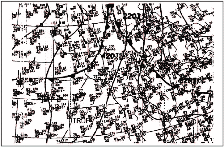
Figure 7: Winds and temperatures aloft forecast. Explanation of figure 7: The heading indicates that this FD was transmitted on the 15th of the month at 1640Z and is based on the 1200 Zulu radiosonde. The valid time is 1800 Zulu on the same day and should be used for the period between 1700Z and 2100Z. The heading also indicates that the temperatures above 24,000 feet MSL are negative. Since the temperatures above 24,000 feet are negative, the minus sign is omitted. A 4-digit data group shows the wind direction in reference to true north, and the windspeed in knots. The elevation at A 6-digit group includes the forecast temperature aloft. The elevation at Denver (DEN) is 5,431 feet, so the lowest reportable altitude is 9,000 feet for the winds and temperature forecast. In this case, “2321-04” indicates the wind is forecast to be from 230° at a speed of 21 knots with a temperature of –4°C. Weather charts Weather charts are graphic charts that depict current or forecast weather. They provide an overall picture of the United States and should be used in the beginning stages of flight planning. Typically, weather charts show the movement of major weather systems and fronts. Surface analysis, weather depiction, and radar summary charts are sources of current weather information. Significant weather prognostic charts provide an overall forecast weather picture. Surface analysis chart The surface analysis chart, depicts an analysis of the current surface weather.
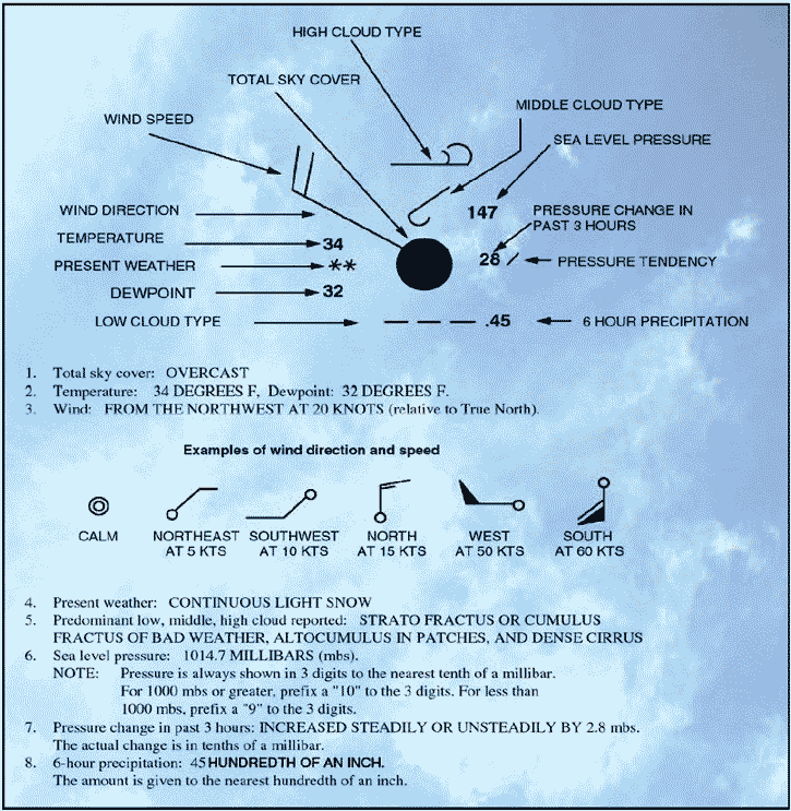
Figure 8: Surface analysis chart. This chart is a computer prepared report that is transmitted every 3 hours and covers the contiguous 48 states and adjacent areas. A surface analysis chart shows the areas of high and low pressure, fronts, temperatures, dewpoints, wind directions and speeds, local weather, and visual obstructions. Surface weather observations for reporting points across the United States are also depicted on this chart. Each of these reporting points is illustrated by a station model.
Figure 9: Sample station model and weather chart symbols. A station model will include:
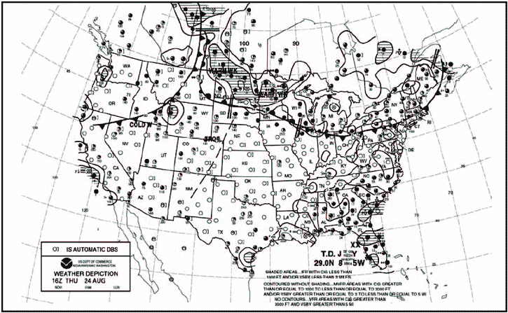
Weather depiction chart A weather depiction chart details surface conditions as derived from METAR and other surface observations. The weather depiction chart is prepared and transmitted by computer every 3 hours beginning at 0100 Zulu time, and is valid at the time of the plotted data. It is designed to be used for flight planning by giving an overall picture of the weather across the United States.
Figure 10: Weather depiction chart. This type of chart typically displays major fronts or areas of high and low pressure. The weather depiction chart also provides a graphic display of IFR, VFR, and MVFR (marginal VFR) weather. Areas of IFR conditions (ceilings less than 1,000 feet and visibility less than 3 miles) are shown by a hatched area outlined by a smooth line. MVFR regions (ceilings 1,000 to 3,000 feet, visibility 3 to 5 miles) are shown by a non-hatched area outlined by a smooth line. Areas of VFR (no ceiling or ceiling greater than 3,000 feet and visibility greater than 5 miles) are not outlined. Weather depiction charts show a modified station model that provides sky conditions in the form of total sky cover, cloud height or ceiling, weather, and obstructions to visibility, but does not include winds or pressure readings like the surface analysis chart. A bracket ( ] ) symbol to the right of the station indicates the observation was made by an automated station. A detailed explanation of a station model is depicted in the previous discussion of surface analysis charts. Radar summary chart A radar summary chart is a graphically depicted collection of radar weather reports (SDs).
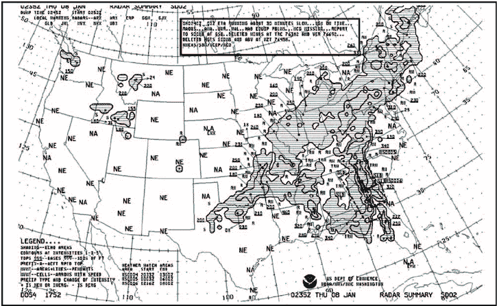
Figure 11: Radar summary chart. The chart is published hourly at 35 minutes past the hour. It displays areas of precipitation as well as information regarding the characteristics of the precipitation.
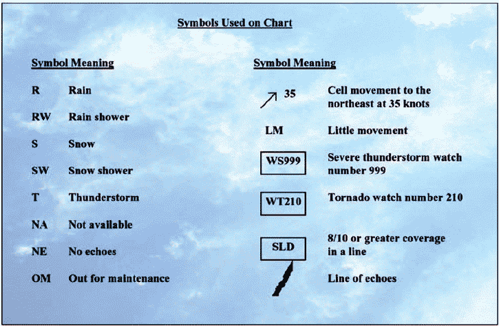
Figure 12: Intensity levels and contours, and precipitation type symbols. A radar summary chart includes:
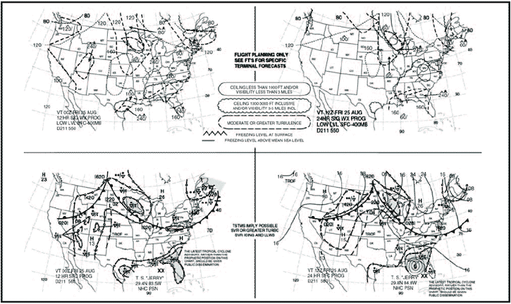
The radar summary chart is a valuable tool for preflight planning. It does, however, contain several limitations for the usage of the chart. This chart depicts only areas of precipitation. It will not show areas of clouds and fog with no appreciable precipitation, or the height of the tops and bases of the clouds. Radar summary charts are a depiction of current precipitation and should be used in conjunction with current METAR and weather forecasts. Significant weather prognostic charts Significant Weather Prognostic Charts are available for low-level significant weather from the surface to FL240 (24,000 feet), also referred to as the 400 millibar level, and high-level significant weather from FL250 to FL600 (25,000 to 60,000 feet). The primary concern of this discussion is the low-level significant weather prognostic chart. The low-level chart comes in two forms: the 12- and 24-hour forecast chart, and the 36 and 48 surface only forecast chart. The first chart is a four-panel chart that includes 12- and 24-hour forecasts for significant weather and surface weather. Charts are issued four times a day at 0000Z, 0600Z, 1200Z, and 1800Z. The valid time for the chart is printed on the lower left-hand corner of each panel. The upper two panels show forecast significant weather, which may include nonconvective turbulence, freezing levels, and IFR or MVFR weather. Areas of moderate or greater turbulence are enclosed in dashed lines. Numbers within these areas give the height of the turbulence in hundreds of feet MSL. Figures below the line show the anticipated base, while figures above the line show the top of the zone of turbulence. Also shown on this panel are areas of VFR, IFR, and MVFR. IFR areas are enclosed by solid lines, MVFR areas are enclosed by scalloped lines, and the remaining, unenclosed area is designated VFR. Zigzag lines and the letters “SFC” indicate freezing levels in that area are at the surface. Freezing level height contours for the highest freezing level are drawn at 4,000-foot intervals with dashed lines. The lower two panels show the forecast surface weather and depicts the forecast locations and characteristics of pressure systems, fronts, and precipitation. Standard symbols are used to show fronts and pressure centers. Direction of movement of the pressure center is depicted by an arrow. The speed, in knots, is shown next to the arrow. In addition, areas of forecast precipitation and thunderstorms are outlined. Areas of precipitation that are shaded indicate at least one-half of the area is being affected by the precipitation. Unique symbols indicate the type of precipitation and the manner in which it occurs.
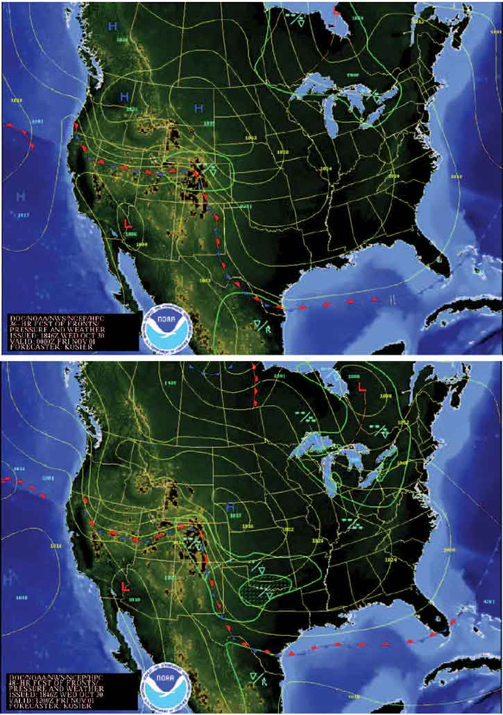
Figure 13: Significant weather prognostic chart. Figure 13 depicts a typical significant weather prognostic chart as well as the symbols typically used to depict precipitation. Prognostic charts are an excellent source of information for preflight planning; however, this chart should be viewed in light of current conditions and specific local area forecasts. The 36- and 48-hour significant weather prognostic chart is an extension of the 12- and 24-hour forecast. It provides information regarding only surface weather forecasts and includes a discussion of the forecast. This chart is issued only two times a day. It typically contains forecast positions and characteristics of pressure patterns, fronts, and precipitation. An example of a 36- and 48-hour surface prognostic chart is shown in figure 14.
Figure 14: 36- and 48-hour surface prognostic chart. This concludes the aviation weather reporting page. You can now go on to the Navigation Basics page or test your knowledge at the FAA Aviation Weather test question bank. |


